


MALESHERBES - FONTAINEBLEAU

NUITEVEN
User
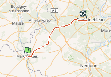

Length
31 km

Max alt
147 m

Uphill gradient
332 m
Km-Effort
35 km

Min alt
68 m

Downhill gradient
368 m
Boucle
No
Creation date :
2017-12-03 00:00:00.0
Updated on :
2017-12-03 00:00:00.0
7h45
Difficulty : Easy

FREE GPS app for hiking
 SityTrail
IGN / Geographical institutes
SityTrail Plus
The world is yours!
About
Trail Walking of 31 km to be discovered at Centre-Loire Valley, Loiret, Le Malesherbois. This trail is proposed by NUITEVEN.
Positioning
Country:
France
Region :
Centre-Loire Valley
Department/Province :
Loiret
Municipality :
Le Malesherbois
Location:
Malesherbes
Start:(Dec)
Start:(UTM)
455607 ; 5349093 (31U) N.
Comments